
Sir Anthony Milbank founded the Moorland Association in 1986. Today, his son Sir Edward is continuing his father’s pioneering work by using cutting-edge LiDAR drones and artificial intelligence to restore peatland. He explains how this technology will help democratise a new carbon and natural capital marketplace to attract corporate ESG investment
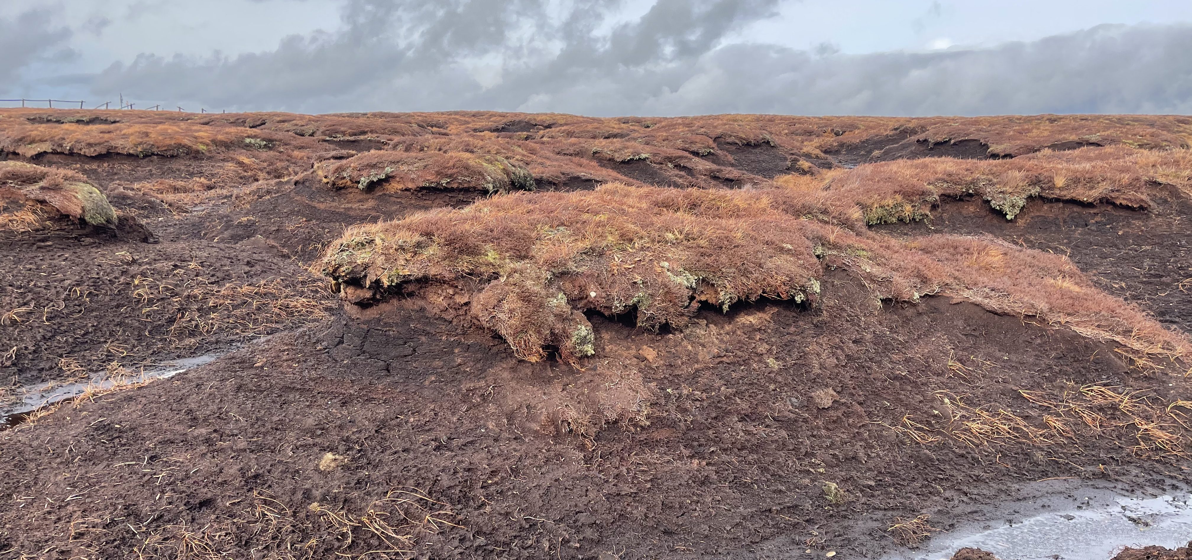
Those of us who are lucky enough to walk around moorlands, both in and out of the grouse shooting season, are only too aware of peaty hags, deep gullies and exposed walls of peat. It’s part of the make-up of the moorland. But it’s these areas, and the crisscross lines of grips, that are causing moorland managers a major carbon headache
Peatlands have tremendous value for carbon storage and each year active peat bogs can sequester several tons of carbon per hectare. In fact, peatlands are the planet’s largest natural terrestrial carbon store. However damaged peatlands emit carbon, and there is now greater focus than ever on restoring these areas.
To put this into context, the Centre for Ecology & Hydrology has estimated that 41% of the UK’s peatlands (1.2 million hectares) has been affected by varying degrees of human activity including drainage, (poor) heather burning and livestock rearing. On England’s upland peatlands, after two decades of restoration work, only 20% of the area needing work has been completed. It’s a mammoth task to restore the balance and we can’t afford to continue at the current speed.
For many moorland managers, finance (or lack of ) is the single biggest obstacle that stands between us and the valuable carbon and ecological benefits that restoration brings. With the CAP based subsidy system coming to an end and the replacement Environmental Land Management (ELM) scheme remaining some way off, some moorland land managers have sharpened their focus on natural capital and the voluntary carbon market as potential alternative revenue.
During 2020, we developed a natural capital account at my home, Barningham estate in the Yorkshire Dales. Whilst the process of engaging with tenants and building an understanding of natural capital has been rewarding, the values attributed to some of the ecosystem services within the monetary flow accounts have left us scratching our heads.
Once you start digging it’s clear to see that much of the natural capital ‘accounting’ is based on assumptions, and there is very limited quality data underpinning the modelled outputs. For example, in our Global Climate Regulation ‘carbon’ account, the moorland areas have been broken down into three conditions with each given a carbon value, backed up by research. So moorland in poor condition has a carbon value of -2.73 CO2 tons/ha/yr, moderate condition is +1.70 CO2 tons/ha/yr and if it considered good condition it is assigned +3.70 CO2 tons/ha/yr.
Whilst it is clear that restoring areas of poor condition to moderate or good would provide a significant uplift to our annual carbon account, what is less clear is the process in qualifying the condition of our moorland. And frustratingly the carbon emittance/sequestration figures proposed by Artz et al. do not seem to correspond with the International Union for Conservation of Nature (IUCN) figures, which underpin the Peatland Code.
On a positive note, there is now clear demand for corporate carbon offsetting, and it appears that businesses may even be prepared to pay a premium for peatland carbon. To turn this carbon demand into realisable finance for peatland restoration, there is a need for confidence in the accuracy of the carbon values attributed to peatland condition and technology to help reduce the cost of peatland restoration.
The issues
Currently the surveying costs needed to provide an assessment of peatland condition prior to restoration is expensive, and there are very few peatland ecologists able to carry out the survey work and to produce an accurate specification of the restoration work required.
The survey process itself generally involves walking the peatland, with the ecologist using their experience to make ground-based assumptions. It’s a time consuming and manual process. In some situations, land managers can access grants to pay for the assessment, but applying for grants is tedious, therefore many projects fall before being considered for restoration.
In addition, due to the limited number of restoration projects proceeding each year, there are very few contractors with the right equipment or expertise to undertake peatland restoration work. Without competition, the incumbent contractors have been able to maintain high prices and therefore the majority of restoration projects are out of the reach of carbon finance and are therefore delivered through public sector grants, which are (again) difficult and time consuming to access.
What is needed is a new system which reduces the costs of the whole process, from initial surveying, the condition assessment, the specification of the works and the restoration work itself. At a reduced cost, and with greater accuracy of measurement, land managers will be able to access corporate carbon finance which will greatly increase the potential for restoration.
This summer we are working with earth observation data and developing artificial intelligence to provide solutions to these issues:
Satellite – peatland condition
Using satellite data and artificial intelligence (AI), we are producing technology which will provide land managers with an accurate condition assessment of their peatlands. The satellite data provides an analysis of moorlands at scale highlighting areas of poor condition, those that are affected by gripping and the areas of exposed peat and gullies, and providing an accurate measurement of the areas that need restoration. This peatland condition data can then be fed into an owners’ carbon account providing an accurate carbon baseline.
Lidar drones – restoration assessment
Light Detection and Ranging (LiDAR) sensors use light energy, emitted from a laser, to scan the ground and measure variable distances. The end result is a rich set of elevation data that can be used to produce high-resolution maps and 3D models of natural and man-made objects. LiDAR drone data and AI can together produce a standardised work specification document for peatland restoration, which can be used for tendering the restoration works.
The importance of LiDAR surveying comes from its capability to generate a volumetric assessment of the damaged peatland area. When analysed by AI, a model of restoration is automatically produced, accurately assessing the quantity of stone/timber/heather bales to be imported, the ideal positioning of dams, the linear meters of grips that need blocking, the area of exposed hag, and the areas that require re-vegetating
There is an additional benefit that comes from the AI generated work specification document, which is the standardisation of the tendering process. We believe this will encourage new contractors to enter the industry, which will increase competition and driving down the cost of restoration.
Technology is becoming increasingly important as a tool for land managers, with affordable data increasing the accuracy of natural capital accounting. And with the cost of drone technology falling, and the number of drone pilots increasing the technology described above will shortly be available to all moorland owners.
So if readers have a business and are keen on corporate social responsibility, this is an affordable technology solution that will help create a sustainable scheme that will ultimately attract ESG investment and in turn pay landowners to manage and restore peatland for carbon storage. According to the IUCN, investment in peatland restoration is needed now to secure the benefits they provide and avoid the costly consequences of their deterioration. FJ